This section of ecology focuses on the movement of energy through an ecosystem and the recycling of matter. In most cases, the energy for an ecosystem starts with the sun. Producers use this energy to make food using the process of photosynthesis. Consumers then eat producers, or other consumers, to get the energy they need. There are several types of consumers...herbivores, carnivores, omnivores, scavengers and decomposers. The decomposers break down waste and return nutrients to the soil.
Matter is recycled in an ecosystem. We will be learning about the water cycle, carbon cycle, nitrogen cycle and phosphorus cycle.
Thursday, May 13, 2010
Friday, April 30, 2010
Ecology
We are currently studying the first of 2 units on ecology. Our first unit focuses on biotic and abiotic factors, limiting factors, biomes and niches. Below are some vusual flashcards to help you study. Scroll over to stop the slide show and advance at your own speed. A study guide and online flashcards can be found under "Important links" to the right.
Friday, March 26, 2010
Never Give Up
I saw this video and thought it was very inspiring. It made me think about life and the choices I make each day. Take a look and let me know what you think.
Tuesday, March 23, 2010
Landforms
We have recently been studying landforms in class. To help us remember some key ideas, we sang the Landform Song. Check out these students' variations of the tune...
Wednesday, February 24, 2010
Erosion
Last week we started learning about weathering, erosion and deposition. Weathering is the process that breaks down rock and other material at Earth's surface. Erosion moves weathered material from one place to another. Deposition is the process where sediment is set down at a new location. (Go Team!)
Running water is the dominant process that shapes the landscape, including California's topography. We modeled erosion by rivers in class. Students were able to observe oxbow lakes, alluvial fans and deltas. Check out the pictures below.
Running water is the dominant process that shapes the landscape, including California's topography. We modeled erosion by rivers in class. Students were able to observe oxbow lakes, alluvial fans and deltas. Check out the pictures below.
Wednesday, February 3, 2010
Topography
This week we started a new unit on maps. Most of our time will be spent looking at topographic maps. Topographic maps tell us about the shape of the Earth. We can see steep slopes, gentle slopes, valleys, ridges, hilltops and more. In addition to natural features, cultural (man-made) features are also placed on these maps. Below is a topographic map of the Travis Ranch area.  This will be a very short unit. A quiz is scheduled for next week... February 12.
This will be a very short unit. A quiz is scheduled for next week... February 12.Friday, January 22, 2010
What a storm!
Can you believe the weather this week? Thunder, lightning, tornado warnings, hail, several inches of rain! Hard to believe we're in southern California. I just took these pictures from the classroom...4:40pm on Friday afternoon. Check out the hail!! 

Friday, January 8, 2010
Monday, January 4, 2010
What's Shaking Trailblazers?
We've been talking a lot about earthquakes. Let's take some time to review what we've learned...
As plates move, stress builds up in the earth. There are 3 types of stress; compression, tension and shearing. Compression squeezes rock, tension pulls rock, and shearing pushes rock in opposite directions. When the stress is released, this caused earthquakes to occur.
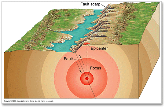
When an earthquake occurs, a fault is created. A fault is a crack in the ground w here blocks of rock have moved past each other. There are 3 types of faults. Normal faults occur as a result of tension. The hanging wall moves down relative to the footwall. Reverse faults are caused by compresion. In this case, the hanging wall moves up. Shearing causes rocks to slide past each other and creates a strike-slip fault. The San Andreas fault is a strike-slip fault.
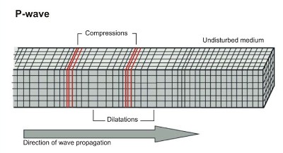
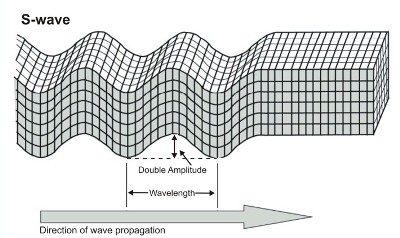
During an earthquake, seismic waves move out from the focus in all directions. Primary waves (or p-waves) are the fastest. They move in a straight line and can travel through solids and liquids. Secondary waves (or S-waves) move more slowly. They travel in a side-to-side motion and can only travel through solids. When the p-waves and s-waves hit Earth's surface, they combine to form surface waves (or L-waves). These are the waves that cause the most amount of damage.
 These seismic waves can tell us a lot about an earthquake. When detected at a seismograph, scientists can use the data to help determine the size of the earthquake and the epicenter. The determine the distance to the epicenter, first determine the time between the arrival of the p-wave and s-waves at a seismograph station. Then use the graph to determine the distace to the epicenter. Next, use a compass to draw a circle around the location of the seismograph station. Repaet this process for 2 other siesmograph stations. The epicenter is located where the 3 cirlces overlap. To practice this, visit the virtual earthquake website.
At this time, scientist cannot predict when an earthquake will occur. However, scientists can determine the seismic risk of an area. Maps are created to show where earthquakes are most likely to occur. Most of these areas are along plate boundaries; however, some earthquake do occur away from plate boundaries.
Hope this summary is helpful to you. Our test will be next week. To study, visit some of the important links posted to the right.
As plates move, stress builds up in the earth. There are 3 types of stress; compression, tension and shearing. Compression squeezes rock, tension pulls rock, and shearing pushes rock in opposite directions. When the stress is released, this caused earthquakes to occur.
When an earthquake occurs, a fault is created. A fault is a crack in the ground w
here blocks of rock have moved past each other. There are 3 types of faults. Normal faults occur as a result of tension. The hanging wall moves down relative to the footwall. Reverse faults are caused by compresion. In this case, the hanging wall moves up. Shearing causes rocks to slide past each other and creates a strike-slip fault. The San Andreas fault is a strike-slip fault.During an earthquake, seismic waves move out from the focus in all directions. Primary waves (or p-waves) are the fastest. They move in a straight line and can travel through solids and liquids. Secondary waves (or S-waves) move more slowly. They travel in a side-to-side motion and can only travel through solids. When the p-waves and s-waves hit Earth's surface, they combine to form surface waves (or L-waves). These are the waves that cause the most amount of damage.
These seismic waves can tell us a lot about an earthquake. When detected at a seismograph, scientists can use the data to help determine the size of the earthquake and the epicenter. The determine the distance to the epicenter, first determine the time between the arrival of the p-wave and s-waves at a seismograph station. Then use the graph to determine the distace to the epicenter. Next, use a compass to draw a circle around the location of the seismograph station. Repaet this process for 2 other siesmograph stations. The epicenter is located where the 3 cirlces overlap. To practice this, visit the virtual earthquake website.At this time, scientist cannot predict when an earthquake will occur. However, scientists can determine the seismic risk of an area. Maps are created to show where earthquakes are most likely to occur. Most of these areas are along plate boundaries; however, some earthquake do occur away from plate boundaries.
Hope this summary is helpful to you. Our test will be next week. To study, visit some of the important links posted to the right.
Friday, January 1, 2010

Subscribe to:
Comments (Atom)